1 Meteorological Research Branch, Environment Canada, Downsview 2 Centre for Research in Earth and Space Science, York University 3 Regional Centre, Toronto Office, Environment Canada 4 Synergistic 5 Zephyr North
On another occasion, deep convection on merging cloud lines resulted in nearly 9 consecutive hours of thunder at London airport, 100 mm of rain and golf ball sized hail in surrounding districts (King and Leduc, 1996) . The cloud lines again appeared to be associated with lake breeze fronts. These events suggest that lake breezes may be important to the generation of summer severe weather in southern Ontario.
There are also hints in the tornado climatology of southern Ontario suggesting lake breeze effects. King (1997) pointed out an apparent maximum in tornado occurrence coincident with the stationary line in Figure 1. Sills (1997) described several cases in which tornadoes formed on lake breezes in otherwise benign synoptic conditions.
There have been a number of studies in other areas linking low level convergence zones, such as sea breezes, with severe convection. In Florida, there is a long history of studies linking sea breezes and convection (Byers and Roodebush, 1948; Pielke, 1974; Blanchard and Lopez, 1985; Wilson and Megenhardt, 1997). Lyons and his colleagues studied many aspects of the lake breeze in the Chicago area including effects on severe storms (Chandik and Lyons, 1971). They found that some storms intensified when they encountered the lake breeze while in others there was little effect. In one case they noted a possible tornado which may have been related to the lake breeze. In Colorado, Wilson and Schreiber (1986) estimated that about 80% of all storms and 95% of strong storms formed near radar-observed boundary layer convergence lines. The convergence lines were ascribed to several causes including topographically induced flows, thunderstorm gust fronts and synoptic scale fronts.
Unfortunately, in the Ontario cases cited, sparsity of data makes it difficult to definitively link lake breezes and severe weather. A pilot field project was conducted in the summer of 1997 to gather supplementary observations and to test several observational technologies. The principal goals were to study cloud lines observed on satellite images and to determine their characteristics in terms of boundary layer convergence and whether they could be identified as lake breeze fronts. Ultimately we wish to determine the role that such convergence lines play in generating severe weather.
Because it was unlikely that we could achieve these goals in a single year, a secondary goal was to build a base of experience on which we could design a more ambitious project for the future.
The experiment was sponsored by the Meteorological Research Branch of Environment Canada in association with the Centre for Research in Earth and Space Science at York University. The University of Western Ontario cooperated by assisting with radiosonde launches from its research station 10 km northwest of London. The principal investigators were P. King of MRB and D. Sills of CRESS.
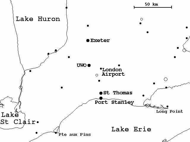
The principal base of operations was the AES radar site at Exeter. At this site we had access via an internet connection to radar and satellite information. In addition it is in the area where the Lake Huron lake breezes occur frequently and is only about one hour from Lake Erie. A secondary base of operations was the UWO research station northwest of London which was used for radiosonde launches.
Figure 2 shows the surface data available for the experiment including standard weather observing stations reporting at one hour intervals, special ELBOW mesonet stations with five minute data, and stations belonging to other agencies such as Ontario Hydro and the Ontario Ministry of Environment and Energy. In addition to these data, regular radiosondes were launched on most days during the IOPs from either the UWO site or the Exeter radar site and kite-borne radiosondes provided serial soundings from ground level to as high as 800m AGL. An aircraft flight was made on 17 July to evaluate wind, temperature and humidity data from an instrument supplied by Aventech Inc. In addition a time-lapse VCR at the Exeter radar site was used to record sky conditions during most of the IOPs.
Lake breeze frontal passages at coastal locations are usually identified by a rapid decrease in temperature and increase in dew point temperature, and a change to a steady onshore wind. Locations further inland typically have a more muted response. These signatures were identified in the Exeter site data only occasionally but were found much more frequently in the St. Thomas and Port Stanley data. This is largely due to the fact that Exeter is more than twice as far inland from Lake Huron as the southern stations are from Lake Erie. However, it was noted during the July IOP that the Lake Erie shore experienced noticeably more lake breeze activity. Thus, the higher frequency may be dependent upon the prevailing synoptic conditions or differences between the lakes themselves.
Figure 3 shows time series data from all three stations on July 10, 1997. Lake breezes penetrated well inland on this day and lake breeze fronts can be easily identified in the temperature, dew point temperature, wind speed and wind direction time series. The Erie front passed the Port Stanley site near 12:40EDT and the St. Thomas site near 14:35EDT. The Lake Huron front passed the Exeter site near 16:50EDT. Note the decreases in temperature and dramatic increases in dew point temperature with the passage of the lake breeze fronts. All three stations show the wind changing from northeasterlies to an onshore flow. Wind speed increases are evident in all but the Port Stanley time series. This would appear to indicate that winds behind the fronts grew stronger as the fronts progressed inland. Conversely, the dew point time series suggests that the moisture gradient decreased as the fronts progressed inland.
As it turned out, we had only one spotter team (D. Sills and X. Qiu) for the experiment supplemented occasionally by the project coordinator (P. King) and the kite team (P. Rodriguez and R. Synergy). However, due to problems with mobile communications, a larger number of spotter teams would likely have resulted in more confusion than useful data.
The spotter team did record significant differences in basic meteorological parameters across some cloud lines but occasionally differences were well below the accuracy thresholds of the instruments. Valuable photographs of developing convection and storm damage were also taken by the team.
We had considerable difficulties with communications. The greatest single problem was poor communications between team members in the field and for the coordinator to obtain access to weather information. We relied on cellular telephones for communication between team members but coverage was inadequate in the area of operations. In a future experiment newer equipment and use of signal boosters might improve coverage. The coordinator relied on a dial up to the internet server located at AES HQ in Downsview for weather information. It was not reliable during regular business hours perhaps due to overloading of the server. In a future experiment we would try to locate the coordinator in a location with full internet access.
The experience gained here should make it easier to coordinate more spotter teams in a future experiment.
Kite-borne sondes offer the tantalizing prospect of making frequent soundings in critical areas. In this case we hoped to make frequent sounding through a lake breeze passage. Unfortunately, lake breezes tended to arrive late in the day at Exeter or else were distorted by the gradient flow.
We had difficulty flying the kite on light wind days when thermals carried the flight up and down capriciously. On days with steady winds the kite flew very well. In addition, the radiosonde station was not mobile restricting our launches to areas close to the ground station. To be useful in a lake breeze study, the kite system must be fully mobile.
There was fine detail in the data which appeared to be qualitatively correct. Unfortunately lake breezes were not well developed that day and we were unable to test if the aircraft data could find lake breeze fronts.
We will give a brief description of three of these events.
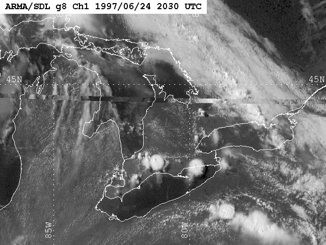
The team proceeded toward the latter line and made several spot measurements while trying to position themselves on the periphery of the storm, which quickly developed into a multicellular cluster. By 2030 UTC (Figure 4(b)) a large cluster had developed just west of London apparently at the intersection of the three lines. The complex continually redeveloped to the northwest effectively cancelling the southeasterly storm motion. This resulted in an extended period of heavy rain over an area to the south of London. Damage from the storm consisted of localized flooding and some downed trees and power lines. There were also unconfirmed reports of golf ball sized hail and a funnel cloud with this storm.
In this event the main spotter team spent the early afternoon hours searching for a lake breeze front off of Lake Huron. After they launched the sonde from the Exeter site and the storm began, they stationed themselves on the southwest edge of the storm while the coordinator made observations on the western periphery of the storm. The coordinator photographed the cloud structure of the complex. The spotter team recorded observations of downed trees and badly flooded roads and fields.
This event clearly appears to be a case of converging lake-induced lines contributing to the development of a severe storm.
The most important feature in a future experiment would be improved communications. Ideally the coordinator would have full internet access to allow for immediate access to various satellite and radar products. Improved communications with mobile teams is also a necessity. We would also install more surface mesonet stations to better delineate the behaviour of lake-induced convergence lines. It can be seen from Figure 2 that there is a large hole in the network in the area between London and Kitchener where it appears that important interactions often take place (and certainly did on July 14). In addition we think that the area just west of London is important when the gradient flow is more westerly. There is also a large hole in the network here.
There would be more and better equipped spotter teams. Spotters might be equipped with mesonet stations which they could install in critical locations on a given day. By installing the anemometer at 7m (instead of the standard 10m), the spotter teams could quickly assembly the station and then disassemble it and move on to another location. This tactic would give better quality measurements than the hand-held instruments used this year.
We were able to launch radiosondes from two sites this year. The ideal situation would be to have at least two fully mobile teams which could launch balloons where and when appropriate.
Our limited experience with the light aircraft indicated that it might form a useful adjunct to a future experiment. A fully equipped aircraft such as the NRC Twin Otter could obviously make more extensive measurements.
Byers, H.R. and H.R. Roodebush, 1948: Cause of thunderstorms on the Florida peninsula. J.Meteor., 5, 275-280.
Chandik, J.F and W.A. Lyons, 1971: Thunderstorms and the lake breeze front. Proceedings. Seventh Conference on Severe Local Storms.
King P., 1996: A long-lasting squall lined induced by interacting lake breezes. Preprints. 18th Conference on Severe Local Storms. February 19-23, 1996, San Francisco CA. 764-767.
Pielke, R.A., 1974: A three dimensional numerical mode; of the sea breezes over south Florida. Mon.Wea.Rev., 102,115-139.
Sills, D.M.L., 1997: Lake breeze triggered thunderstorms: Do they pose a significant severe weather threat? Presented at the 32nd Annual Congress of the Canadian Meteorological and Oceanographic Society, June 1997.
Wilson, J.W. and W.E. Schreiber, 1986: Initiation of convective storms at radar-observed boundary-layer convergence lines. Mon.Wea.Rev., 114, 2516-2536.
Wilson J.W. and D.L. Megenhardt, 1997: Thunderstorm initiation, organization, and lifetime associated with Florida boundary layer convergence lines. Mon.Wea.Rev., 125,1507-1525.