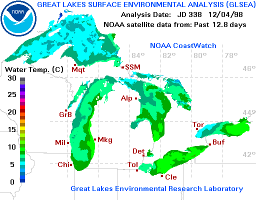
At the same time, lake surface temperatures were gradually beginning
to cool by December 4. Satellite infrared measurements of lake surface
water temperature for this day are shown below.
Lake Ontario surface temperatures near Toronto ranged from near 5C near the lakeshore to 9C nearer to the eastern basin of the lake. Buoy water temperature measurements in western Lake Ontario (not shown) ranged between 5C and 6C on this day, supporting the satellite measurements. However, in contrast to the October 30 case, the buoy air temperature increased to as high as 14C by 1400 EST. As will be shown in the data below, that is only about 2C cooler than the inland temperature at Pearson Airport at 1400 EST but also about 2C warmer than the air temperature at Toronto Island.
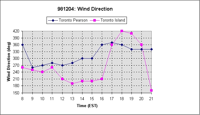
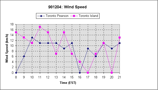
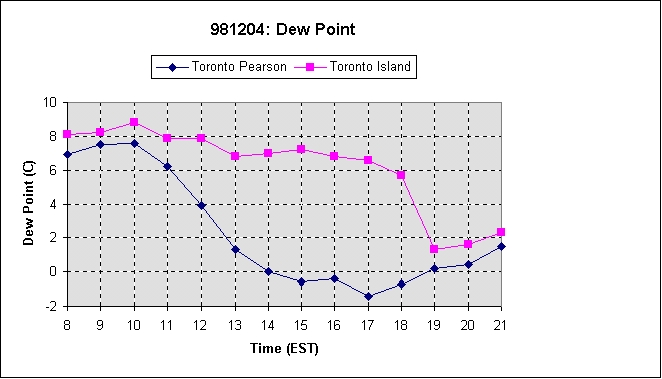
A lake breeze was detected at the Toronto Island station as shown in
the graphs below comparing basic meteorological parameters at Toronto's
Pearson International Airport and Toronto Island. The lake breeze arrived
at the Toronto Island station between 11 EST and 12 EST. The wind at this
station began to back to southerly and the temperature decreased significantly
at this time. By 17 EST, the lake breeze was no longer affecting the Toronto
Island site. The differences in the meteorological parameters at the two
stations are less pronounced than for the October 30 case. However, the
lake breeze signatures are still clear in the time series data.

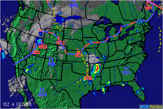
Much of southern Ontario was situated under a surface pressure pattern known as a 'col' - essentially the point of intersection of a trough and a ridge. This resulted in relatively light surface gradient winds through the afternoon. A quasi-stationary front was positioned in the trough just to the north of the region.
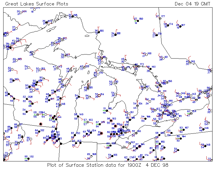
The following surface station plot (courtesy of Ohio State University)
over the Great Lakes at 1900 UTC or 1400 EST shows divergent flow over
of the western basin of Lake Ontario with onshore winds at Toronto Island
and St. Catharines. Onshore flow in other areas along the Lake Ontario
shores and the shores of Lake Huron might also be associated with lake
breezes.
Skies over the area were mainly clear near Lake Ontario with thickening
cloud to the southwest as indicated by the following GOES-8 satellite images
valid at 1902 UTC or 1402 EST.

From this image, it appears that the lake breeze front near Toronto caused no cumulus clouds to form or at least clouds too small to be detected by satellite. Doppler radar data from the King City radar approximately 40 km north of Toronto (not shown) also could not detect a lake breeze front (fine line signature).
Due to the absence of a lake breeze signature in the remote sensing data, I decided at 15:45 EST to investigate the degree of inland penetration by vehicle. I travelled south from the King City radar facility toward Toronto on Highway 400 then on Black Creek Drive. Flags were showing a northerly wind direction. There appeared to be a orange/brown layer of air on the southern horizon.
At roughly 6 km from the lakeshore, I saw a flag that showed a southerly
wind of about 5-10 knots. The flag was about 20m above ground level on
the top of a building. In contrast to the October 30 case, I could not
visibily detect a change in moisture content near the wind shift line.
However, there were once again no clouds to be seen. I stopped to take
a spot measurement near the corner of Keele St. and St. Clair Ave. at 1620
EST. I was using a hand anemometer and a digital thermometer/hygrometer.
Wind directions were obtained with the use of flags and knowledge of the
direction of roadways. I obtained the following observations:
I did notice, however, that the temperature was falling rapidly and the humidity was increasing correspondingly. In the few minutes that I was at this site, the temperature dropped close to 3C. As I left the site, I noticed that the flag there was now showing a southerly wind. Aha! The lake breeze front had just passed as I was taking the measurements. That explains the rapidly falling temperatures as well (though the temperature was likely also falling slowly due to the time of day). Thus, the lake breeze front was advancing even after the sun had set.
I tried again to get on the north side of the front by driving north
along Black Creek Dr. to Highway 401, about 10km from the lakeshore. A
spot measurement at 1701 EST gave the following observations:
I assumed that the lake breeze circulation had weakened considerably
by this time and decided to head toward the lakeshore. The Eglinton and
Jane site appeared to have a light easterly wind as I drove by at 1713
EST. I arrived at the lakeshore at 1737 EST and proceeded to take another
spot measurement near the beach. The observations were:
Again, the temperature was falling rapidly and the humidity was increasing correspondingly. It would appear that the marine air was being slowly advected back toward the lake at this point. However, it is not clear if the front had retreated toward the lake or if the front (which was still advancing at 1647 EST) broke free from the weakening circulation - essentially becoming a 'cut-off vortex' as described by John Simpson in the UK.
This lake breeze event has some interesting similarities and differences with the October 30 case.
Similarities
In both cases, the lake breeze front reached Toronto Island between 11 EST and 12 EST and penetrated inland 6 or 7 km. Also, though the circulation was evident in the surface observations, the lake breeze front could not be detected by satellite or by Doppler radar. No clouds were produced at the lake breeze front in either case.
Differences
The most significant differences are the air and water temperatures at the buoy. In the December 4 case, the buoy air temperature is warmer than the buoy water temperature - the reverse was true on October 30. Also, there is a much smaller lake-land air temperature difference. However, winds for the December 4 case were relatively light. Thus, nearly the same degree of penetration was achieved. Another difference is the change in moisture content across the front which appears to be less significant in the December 4 case. There was no visible change in the moisture content of the air. This may, however, be due to factors other than the moisture content such as the presence of pollutants, etc.
Overall, the two events serve to confirm that lake breezes can occur in southern Ontario at almost any time of the year - if the conditions are right!