Paper 2.5, AMS Severe Local Storms Conference,
14-18 September 1998
THE 1997 ELBOW PROJECT:
HIGH-RESOLUTION MODELLING OF LAKE BREEZES
IN
A PRE-STORM ENVIRONMENT
David
M. L. Sills
York
University, Toronto, Ontario
Patrick
King
Meteorological Research
Branch, Environment Canada, Toronto, Ontario
1. INTRODUCTION
The Effects of Lake Breezes
On Weather (ELBOW) project investigates the role of lake breezes in the
occurrence
of severe weather in southern Ontario, Canada, using data collected
during the
summer of 1997. One goal of the project is to examine the nature of
lake-induced cloud lines that tend to occur in association with
moderate
surface winds, especially those from the southwest that blow along
parallel
Lake Huron and Lake Erie shoreline segments. These lines have been
implicated
in the initiation of severe weather (King, 1996). However, their nature
has
been difficult to characterize due to sparsity
of
observational data in the region, ambiguous signatures in satellite and
surface
data, and suspected frictional and topographical effects. For this
study,
GOES-8 visible satellite imagery, ELBOW field observations, and
mesoscale
numerical modelling results are used to elucidate the origins and
evolutions of
lake-induced cloud lines that preceded severe weather on July 14, 1997.
2. OBSERVATIONAL
DATA AND ANALYSIS
On July 14, 1997, a
moderate southwesterly surface wind was accompanied by inland
temperatures up
to 34°C and unusually high dew point
temperatures up to 27°C. Lake surface temperatures
ranged from a minimum of 16°C on Lake Huron to a maximum of
24°C
on western Lake Erie. Though synoptic-scale dynamics were favourable
for the
formation of strong thunderstorms in areas to the southwest and
northeast of
the Great Lakes region, dynamics over the study area were quite weak.
Two lines of cumulus clouds
developed between Lake Erie and Lake Huron aligned with the
southwesterly
surface wind after 1300 LST (Local Standard Time). The lines appeared
to
originate from headlands along the north shore of Lake Erie. These
cloud lines
remained nearly stationary with respect to the shore while gradually
extending
farther inland to the northeast. A line of cumulus clouds extending
inland from
the south shore of Lake Huron toward the northeast became apparent at
1500 LST.
Skies over nearby lake areas were cloudless. Though observed surface
winds
showed no strong deviations from southwesterly flow near the
shorelines,
differences in air temperatures over land and lake surfaces exceeded 10°C
at times.
Figure 1 shows the satellite image valid at 1545 LST. The
positions of cloud lines inferred from animated satellite images are
indicated
using dashed lines. Two distinct lines are still evident north of Lake
Erie.
Enhanced convection is apparent where Lake Huron and Lake Erie lines
converge.
Showers and thunderstorms were also forming at lines northwest of Lake
St.
Clair and near western Lake Huron. Convective debris from thunderstorms
initiated at a cloud line along Lake Erie's south shore is evident over
Lake
Erie. Convective debris from morning showers and thunderstorms is also
visible
east of Lake Huron (outflow boundaries from these storms did not appear
to
influence afternoon convection). The ELBOW base station at Exeter
(labelled
'A') had a temperature of 33°C and a dew point of 25°C
at 1545 LST. The temperature at 'B' was 32°C
while the temperature and dew point were 31°C
and 26°C at 'C'. Winds at these
stations suggest mesoscale surface convergence.
A radiosonde launched from the Exeter base station near this time gave
a
surface-based CAPE exceeding 6000 J kg-1, storm motion
from 300° at 7 m s-1, and
a 0-3 km storm-relative helicity value
near 160 m2 s-2. Unusually high dew points were
confined
to the near-surface layer of the sounding and were likely the result of
enhanced evapotranspiration following morning showers and
thunderstorms.
After
1545 LST, a few thunderstorm cells rapidly developed at the apparent
point of
merger of Lake Huron and Lake Erie cloud lines. These cells evolved
into a
quasi-stationary multicell cluster that appeared to be anchored to the
point of
merger. This storm produced approximately 200 mm of rain in five hours
at
locations about 50 km east of Exeter. Localized flooding, wind gusts to
115 km
h-1 and hail were reported. Storms initiated at convergence
lines
along the shores of eastern Michigan intensified and moved east into
southwestern Ontario after 1900 LST. King and Sills (1998) provide
additional
details regarding the ELBOW field campaign and analysis of events on
this day.
3. THE
MESOSCALE NUMERICAL MODEL
To investigate the
three-dimensional
structure and evolution of these cloud / convergence lines, we used a
fully
compressible, non-hydrostatic, mesoscale model developed by the
University of
Québec at Montréal and Environment Canada. This model, called the
Mesoscale
Compressible Community (MC2) Model (Benoit et al., 1997), is linked to
a
comprehensive and well-tested physics package. An attractive feature of
the
model is its self-nesting capability.
To obtain results on a fine grid mesh,
the self-nesting strategy shown in Table 1 was used. Initial and
boundary
conditions for the coarse run were provided by analyses at six hour
intervals
from an Environment Canada global model. For each run, we used 28
vertical
levels with 11 levels in the lowest 1.5 km and a lid near 24 km.
Initial geophysical
fields for the various model runs were based on climate data if
case-specific
data could not be found. High resolution topography, land-sea mask,
surface
roughness, and lake surface temperatures were obtained for the 5 km
grid run.
Since no convective parameterization scheme was available for a
simulation
with 5 km grid spacing, the focus of the modelling experiment was on
identifying mesoscale structures in the pre-storm environment rather
than the
dynamics associated with storm initiation.
TABLE 1
|
Model Run
|
Grid Size (km)
|
Time Step
(min)
|
Coverage
Area
|
|
coarse
|
100
|
20
|
Canada/US
|
|
medium
|
25
|
5
|
Great Lakes
|
|
fine
|
5
|
1
|
SW Ontario
|
4. MODEL
RESULTS AND ANALYSIS
The fine-scale (5km) model
run for July 14,1997, was initialized at 0700 LST and was carried out
to 1900
LST. The development of convergence lines was studied using
cross-sections and
animations of various fields such as the horizontal and vertical wind
fields.
Weak lake breezes began to form by 0800 LST but were limited to about
250 m in depth. As the circulations increased in strength and
depth, they
were shifted downwind by the southwesterly flow causing lake breeze
fronts to
stretch toward the northeast. By 1130 LST, lake breeze circulations had
grown
to about 750 m in depth and lake breeze fronts along the shores of
eastern
Michigan began to link together. Lake breeze circulations were near
their
maximum depth at 1600 LST with updraft regions reaching up to 2000 m in
height.
Figure 2 shows positive
vertical motion at 625 m valid at 1600 LST with the surface wind field
superimposed. Several convergence lines are apparent. The strongest is
the line
associated with the linked lake breeze fronts along the eastern shores
of
Michigan from western Lake Erie to western Lake Huron. Other strong
convergence
lines are associated with lake breeze fronts along the north and south
shores
of Lake Erie with the convergence line north of Lake Erie extending
inland to
the northeast. A much weaker convergence line associated with a lake
breeze
front south of Lake Huron also extends inland to the northeast.
Another weak
line is located over inland southeastern Michigan northwest of Lake St.
Clair.
The general pattern of
lines is similar to that indicated in the Figure 1 though the observed
lines
north of Lake Erie appear to be located farther inland. A cross-section
through
both the Lake Huron and Lake Erie convergence lines is shown in Figure
3 valid
at 1600 LST. The Lake Huron lake breeze circulation has its western
front over
the western side of the lake and its descending branch nearly over the
southern
shore. Its southern front is much weaker and is located near the
southern
shore. The Lake Erie front is located well inland. Air temperatures
over land
exceed 32°C while much cooler temperatures
between 22°C
and 24°C are evident over the lakes. A
nearly dry adiabatic lapse rate near 9°C km-1 exists in the
lowest kilometre over land while strong
temperature inversions are evident over the lakes.
Based on these and other
cross-sections, and animations of the development of these lines, it is
believed that most of the cloud lines indicated in Figure 1 are indeed
lake
breeze fronts though the front south of Lake Erie is likely enhanced by
the
steep topography there and a topographic feature is likely the cause of
the
convergence line over inland southeastern Michigan. Clearly, lake
breeze
circulations and their associated fronts are highly perturbed by the
large-scale wind field.
Weak, modelled convergence
lines also appear along the eastern shore of Lake Huron and the
northern shore
of central Lake Erie (Figure 2). Animations show that these lines are
nearly
stationary over the shorelines. We believe that they are caused by
frictional
drag as fast-moving air over water encounters the rough and quickly
rising
terrain. Potential temperature profiles over these areas (not shown)
give
boundary layer heights of less than 100 m. Thus, clouds would not be
expected
to form with these convergence lines and are not apparent at those
locations
in the satellite imagery (Figure 1).
Finally, Figure 4
summarizes the suggested causes of convergence and cloud lines at 1545
LST
based on satellite and surface observations and the MC2 model output.
5. CONCLUSIONS
Based on GOES-8 visible
satellite imagery, observations collected during the ELBOW field
campaign, and
simulations with the MC2 mesoscale model, we find that:
1) the pattern
of convergence
lines that developed on July 14, 1997, was a complex combination of
highly-perturbed lake breeze fronts, topographical effects and
frictional
effects with observed cloud lines being associated mainly with lake
breeze
fronts, and
2) thunderstorms were initiated along many of
these convergence lines
including a severe thunderstorm that appeared to be initiated at and
anchored
to the merger point of Lake Huron and Lake Erie lake breeze fronts.
REFERENCES
Benoit,
R.; M. Desgagné, P. Pellerin,
S. Pellerin, Y. Chartier,
S. Desjardins, 1997: The Canadian MC2: A Semi-Lagrangian,
Semi-Implicit Wideband Atmospheric Model Suited for Finescale
Process Studies and Simulation. Mon. Wea.
Rev.,
125:2382-2415.
King,
P., 1996: A long-lasting squall line induced by interacting lake
breezes. Preprints,
18th Conference on Severe Local Storms. Amer. Meteor. Soc., 764-767.
King,
P. and D.M.L. Sills, 1998: The 1997 ELBOW
Project: An Experiment to Study the Effects of Lake Breezes on
Weather
in Southern Ontario. In this volume.
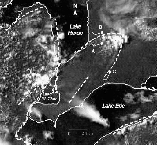
Figure 1. GOES-8 visible satellite image
valid at 1545 LST showing cloud
lines (indicated by dashed lines on the lakeward
edges). 10 m winds at A, B, and C are in knots (1 m s-1 =
1.9 knots)
with a full barb indicating 10 knots. 1.5 m temperatures and dew point
temperatures at these stations are discussed in the text.
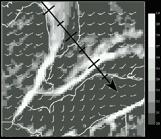
Figure 2. Vertical motion at 625 m and the 10
m wind field valid at 1600
LST as output by the MC2 model. The shaded vertical motion scale at the
right
of the figure is in units of 10-1 m s-1. Winds are shown as in Figure 1 (circles
represent calms). The arrow gives the location for the cross-section in
Figure
3. Note that part of the arrow runs off the image.
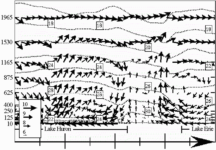
Figure 3. Vertical cross-sections through the
combined horizontal and
vertical wind fields and the air temperature field along the arrow
marked in
Figure 2. Vertical levels at left are in metres. The wind arrow scale
in knots
(1 m s-1 = 1.9 knots) is shown at bottom left. Vertical
velocities
are multiplied by 50. Dotted lines are temperatures contours at 2°C
intervals. The horizontal extents of Lakes Huron and Erie are
indicated by the labelled lines near the bottom. The length of the
arrow is
approximately 300 km.
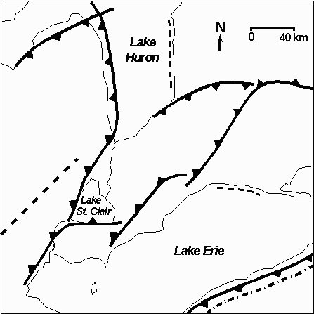
Figure 4. Map showing the suggested
arrangement of lake breeze fronts
(cold front symbol) and frictional (dashed line) and topographic
(dash-dotted
line) convergence zones at 1545 LST on July 14, 1997.