Paper 7.1, AMS Severe Local Storms Conference, 11-15 September 2000
LANDSPOUTS AT LAKE BREEZE FRONTS IN SOUTHERN ONTARIO
David M.L. Sills
Patrick W.S. King
King Nowcasting Group, Meteorological Research Branch,
Environment Canada, King City, Ontario
1. INTRODUCTION
'Landspout' is one of several terms introduced in the 1980s by Bluestein (1985), Brady and Szoke (1989) and Wilson and Wakimoto (1989) to describe a type of tornado associated with thunderstorms not possessing a strong mid-level mesocyclone. Using observational data from Colorado, these researchers found that landspouts developed in relatively benign (weakly shear and weakly forced) synoptic-scale conditions when a vigourous convective updraft vertically stretched and intensified a pre-existing, surface-based region of concentrated vertical vorticity. These vorticity centres had diameters less than 2 km and were therefore called 'misocyclones' after Fujita (1981). Thus, though they are widely known for their dynamic and visual similarities to waterspouts, landspouts may be more accurately called 'misocyclone tornadoes'. They can cause up to F3 (Fujita, 1981) damage and occur frequently in parts of both Colorado and Florida (Lee and Wilhelmson, 1997).
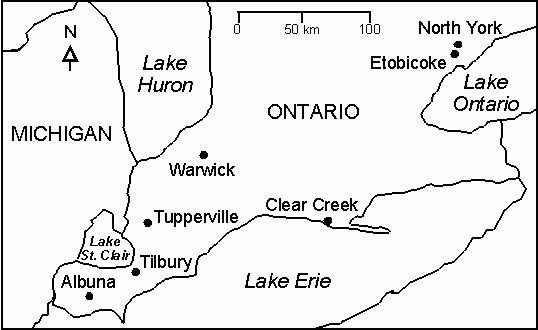
A systematic relationship between lake breezes and the tornado climatology of southern Ontario was first suggested by King et al. (1996). Subsequently, through extensive work with both the tornado and lake breeze climatologies of southern Ontario, we have identified seven landspout events (Figure 1). Each of these landspouts occurred under rapidly-developing thunderstorms in the vicinity of one or more lake breeze fronts - mesoscale boundaries that are rich sources of shear-induced vertical vorticity.
With this paper we will attempt to show that landspouts do occur in southern Ontario, often in association with lake
breeze fronts, and that they may make up a significant fraction of tornadoes occurring in the region each year. We will
also explore the possibility that the landspout formation process may be responsible for other phenomena often
reported in the vicinity of lake breeze fronts including funnel clouds, dust whirls and even some mesocyclone
tornadoes.
2. METHODOLOGY
Based on the work done in Colorado, we arrived at the following criteria to identify landspouts:
We also developed criteria to identify whether the landspout occurred at or near the location of a lake breeze front. A
lake breeze front was considered to be present in the affected region if any two of the following were found:
In some cases, weak outflow boundaries may also have played a role in landspout development but could not be identified using the available data.
The availability of archived data for identifying landspouts at lake breeze fronts varied considerably from case to case but was generally quite limited. Doppler radar data were available in only a few documented cases so for most events mesocyclones could not be explicitly discounted. In a few cases, data were gleaned from previously published reports.
Figure 1. Map showing southern Ontario and the locations of seven landspout events.
3. RESULTS
Both the landspout and lake breeze criteria appear to be met for seven cases. Table 1 gives the dates, locations and relevant data for each of these landspout events. These locations are marked on the map in Figure 1. In all cases, the tornado occurred as the parent thunderstorm was undergoing rapid development. In at least three cases, tornado movement was against the mean tropospheric flow. This is a rare feature for Ontario tornadoes. Multiple funnels were also reported in three of the events. The tornadoes caused damage ranging from F0 to F2. In the one event (17 September 1989) where Doppler radar data were available, weak, non-persistent rotation couplets were detected with cells present previous to the development of the parent cell and also as the parent cell was undergoing rapid growth. The next section describes one event, the landspout of 15 August 1993, in detail.
TABLE 1
| Date | Location | F-Intensity | Movement |
| 84 08 141 | North York | F2 | ENE - WSW |
| 88 09 172 | Etobicoke | F0 | n/a |
| 91 05 313 | Albuna | F0 | n/a |
| 93 07 10 | Warwick | F0* | n/a |
| 93 08 14 | Tupperville | F0 | NE - SW |
| 93 08 15 | Tilbury | F0 | ENE - WSW |
| 99 08 04 | Clear Creek | F1 | WSW - ENE |
1, 2, 3 - reports by Bertolone (1984), Hogue et al. (1989) and Murphy (1991), respectively; * estimated from video - no damage reported
3.1 The Tilbury Landspout
On the morning of 15 August 1993, southern Ontario continued to be in a stagnant weather pattern dominated by a large surface ridge. A weak surface low was beginning to develop west of the Great Lakes region in response to a weak 500 hPa trough over the central part of the continent. Showers and thunderstorms were widespread just ahead of this system. In southern Ontario, there was no significant synoptic-scale forcing due to fronts or thickness advection. However, the gradient wind over the region did begin to increase from the southwest during the afternoon ahead of the approaching low.
The 12Z sounding from Flint, Michigan, shown in Figure 2, indicates an environment with moderate instability generating Convective Available Potential Energy (CAPE) near 1700 J kg-1 (using the most unstable layer in the lowest 300 hPa and virtual temperature). When the sounding is modified with the surface temperature and dewpoint observed at Tilbury before the occurrence of the landspout (29C, 23C), the CAPE increases to 3600 J kg-1. No capping inversion is evident. Winds veered from south to northwest from the surface to 400 hPa but the wind speed was below 20 knots through this entire layer. The computed storm-relative helicity (0-3 km) was only 23 m2s-2. Therefore, though thunderstorms were possible, they were unlikely to possess a strong mesocyclone at mid-levels.
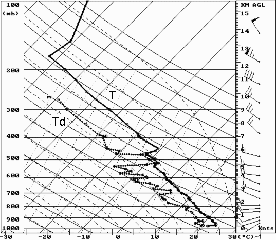
Figure 2. Skew-T log P diagram with sounding data from Flint, Michigan at 12Z on 15 August 1993.
Winds are in knots.
Data from surface stations in the region, including a project mesonet, showed that onshore flow began on the Lake Erie shore at 0825 EDT indicating the arrival of the lake breeze. Onshore lake breeze flow commenced on the Lake St. Clair and Lake Huron shores at 1020 EDT. The lake breeze winds were light at about 5 knots. At 1400 EDT, surface air temperatures ranged from 30C inland to 24C over Lake Erie while dew point temperatures ranged from 18C to 24C. The lake breezes from Lake Erie and Lake St. Clair resulted in opposing flow near Tilbury from 1020 EDT to 1455 EDT, or for 4 hours and 35 minutes. Convergence, calculated using data from three nearby mesonet stations, increased steadily from 0800 EDT to about 1300 EDT reaching a maximum of 34 x 10-5 s-1. Surface winds and estimated lake breeze front positions at 1400 EDT, the time the landspout was occurring, are shown in Figure 3.
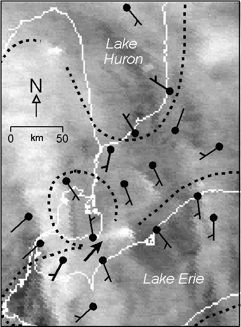
Figure 3. Visible satellite image and surface winds (knots) at 1400 EDT.
Dashed lines show the estimated positions of lake breeze fronts (except
near thunderstorms). The arrow points to Tilbury.
GOES-7 visible satellite imagery indicates a line of cumulus clouds in this region of convergence, parallel to both the Lake Erie and Lake St. Clair shores, beginning at 1200 EDT. A deck of thin, broken cirrus present over the region makes it difficult to see the line before this time.
Radar echoes first appeared over southern Ontario near 1330 EDT near Tilbury. A thunderstorm quickly developed to the east of the town and remained nearly stationary for about one hour. Maximum radar reflectivities in the storm core at 1345 EDT ranged from 50 dbZ to 57 dbZ. Several dust whirls and funnel clouds were reported and at least one weak tornado occurred in Tilbury at this time. The tornado, shown in Figure 4, had a thin, rope-like appearance. Witnesses reported that the vortices occurred under cloudy but precipitation-free skies with audible thunder and distant lightning suggesting that the thunderstorm flanking line may have been aligned along the lake breeze convergence zone. In addition, witnesses reported that the tornado began moving east toward the storm core and into Tilbury then moved back along nearly the same path to the west-southwest before dissipating. This appears to indicate tornado motion parallel to the lake shore and suggests a link to the lake breeze convergence zone in the vicinity. We think that the tornado began to move along the convergence zone in the direction of the gradient wind but was forced back along the convergence zone by the thunderstorm outflow. This hypothesis is supported by surface observations to the northwest and south of Tilbury that indicate gust front passages at 1455 EDT and 1505 EDT, respectively. The maximum wind gust recorded with the passage of the gust front was 13 knots. Also, video and photographs of the landspout show that it was tilted back toward the east indicating flow near the surface from that direction.
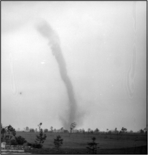
Figure 4. Photograph of the Tilbury landspout taken facing south
at about 1405 EDT by Gerry Harvieux of the Tilbury Times.
The tornado was moving from east to west at this time.
At the time of the tornado, the thunderstorm was undergoing explosive growth. The visible satellite image at 1400 EDT, shown in Figure 3, reveals a bright, compact area of cumulus cloud about 10 km east of Tilbury with a line of cumuli trailing west into Tilbury. The next image at 1430 EDT (not shown) shows a 40 km long anvil blown off to the southeast. Radar indicates that the thunderstorm had moved only about 15 km to the east-southeast of Tilbury at this time.
There were three other areas where thunderstorms developed rapidly on this day. One is indicated in Figure 3 by the small, bright area of cumulus cloud over Michigan to the west of Lake Huron. Two other quasi-stationary thunderstorms developed inland from Lake Erie east of Tilbury between 1430 EDT and 1730 EDT giving heavy rain. Each of these also appeared to be focussed on a lake breeze front. A narrow region of enhanced lift at upper-levels indicated by the band of cirrus visible just west of Tilbury at 1400 EDT appeared to contribute to the activity on this day as it moved from west to east.
The Tilbury landspout was visible for about 15 minutes covering a total path of about 10 km. The tornado caused some minor building, crop and tree damage and pushed a car into the opposing lane suggesting an F0 intensity. Witnesses reported that the funnels came from the base of an ordinary-looking cumulus cloud. Photos and video also show no indications of a wall cloud. Overall, the characteristics of this landspout appear quite similar to those of the landspouts studied in Colorado.
4. DISCUSSION
The seven landspouts identified share the following common characteristics with those studied in Colorado:
There is one noteworthy difference, however. The Colorado landspouts occurred in environments with modest CAPE values typically lower than 1000 J kg-1. In most of the cases presented here, CAPE values were higher than 1000 J kg-1 and on some days reached over 3000 J kg-1. Some of this difference may be due to differences in the calculation of CAPE. However, it may also be possible that misocyclones along lake breeze fronts in this region require a somewhat stronger convective updraft to spin-up to tornadic intensity.
There are typically 20-30 tornadoes reported in Ontario every year. Nearly all of these cause F2 damage or less, are brief and have short tracks. In addition, the influence of lake breezes on the tornado climatology of the region is readily apparent. A very small number of tornadoes have occurred in locations frequently in 'lake shadow' while numerous tornadoes have been recorded in corridors between the lakes. Only a small number of these have been studied in detail. We believe that a large portion of the tornadoes reported each year in this region may be of the landspout variety.
The main ingredients in landspout formation process are a strong updraft and a surface-based misocyclone. Updrafts of the strength required to intensify a misocyclone to tornadic proportions occur frequently in association with thunderstorms. In southern Ontario, the mean number of days with thunderstorms per year ranges from about 20 to 35 depending on the location. However, lake breezes and their fronts occur on roughly 50% of summer days in southern Ontario (Sills, 1998). Misocyclones generated by shearing instabilities along lake breeze fronts probably occur quite frequently in the region (the situation is similar to parts of Florida in this regard). What happens on those days without thunderstorms when convective updrafts are not strong but are weak to moderate? We are beginning to find evidence in southern Ontario that a weak to moderate updraft is able to spin-up the surface-based vertical vorticity but only to sub-tornadic proportions. This results in a vortex that is occasionally made visible by dust at the surface or a condensation funnel aloft. It appears that these vortices have been reported and interpreted by meteorologists as either dust devils or cold air funnels, depending on the synoptic-scale situation. However, these vortices may actually be under-developed landspouts. As such, they may indicate the potential for a tornado if stronger updrafts are present nearby or are expected to develop in the area.
On the other end of the spectrum, what if the updraft is intense as is often the case with mesocyclones? Again, we are beginning to find evidence in southern Ontario that some of our strongest tornadoes develop when a supercell thunderstorm crosses or moves along a lake breeze frontal boundary. Is such a vortex a mesocyclone tornado or a landspout?
We suggest that all of these vortices are really the same phenomena but with varying degrees of intensity based on the strength of both the updraft and the misocyclone. We are actively collecting evidence to support this hypothesis. If true, this may be fortunate since both significant updrafts and boundaries with misocyclones may be detected (currently with varying degrees of success) using operational platforms such as Doppler radar, visible satellite imagery and surface data. Future nowcasting research might be directed toward improved detection of these features.
5. CONCLUSIONS
The low-level vertical vorticity provided by the highly-sheared environment along a lake breeze front appears to be sufficient for the development of landspouts when co-located with the updraft region of a rapidly-developing thunderstorm. As in Colorado, these tornadoes are typically weak, brief and appear to move along mesoscale boundaries independent of the mean tropospheric flow. A significant portion of the tornadic and sub-tornadic vortices that occur each year in southern Ontario may develop by this process.
ACKNOWLEDGEMENTS
This work was funded by Environment Canada. Thanks to Mike Leduc, Brian Murphy and those who recounted their landspout tales for their input to this work.
REFERENCES
Bertolone, L., 1984: The Metropolitan Toronto tornado of August 14, 1984. Ontario Region Technical Note No. 84-9, Atmospheric Environment Service, Toronto.
Bluestein, H.B., 1985: The formation of a "landspout" in a "broken-line" squall line in Oklahoma. Preprints, 15th Conference on Severe Local Storms, Indianapolis, Amer. Meteor. Soc., 267-270.
Brady, R.H. and E.J. Szoke, 1989: A case study of nonmesocyclone tornado development in northeast Colorado: similarities to waterspout formation. Mon. Wea. Rev., 117, 843-856.
Fujita, T.T., 1981: Tornadoes and downbursts in the context of generalized planetary scales. J. Atmos. Sci., 38, 1511-1534.
Hogue, R., P. Joe and T.R. Nichols, 1989: The 17 September 1988 weak tornadic storm in Metro Toronto. Ontario Region Technical Note No. 89-2, Atmospheric Environment Service, Toronto.
King, P., M. Leduc and B. Murphy, 1996: The climatology of tornadoes in southern Ontario: Possible effects of lake breezes. Preprints, 18th Conference on Severe Local Storms, San Francisco, CA, Amer. Meteor. Soc., 627-630.
Lee, B.D. and R.B. Wilhelmson, 1997: The numerical simulation of non-supercell tornadogenesis. Part I: initiation and evolution of pretornadic misocyclone circulations along a dry outflow boundary. J. Atmos. Sci., 54, 32-60.
Murphy, B.P., 1991: Tornado and flash flood in southwestern Ontario on 31 May 1991. Ontario Region Technical Note No. 91-3, Atmospheric Environment Service, Toronto.
Sills, D.M.L., 1998: Lake and land breezes in southwestern Ontario: observations, analyses and numerical modelling. PhD thesis, York University, 338 pp.
Wilson, J.W. and R.M. Wakimoto, 1989: Non-supercell tornadoes. Mon. Wea. Rev., 117, 1113-1140.