Storm Damage Survey - 17 July 2000
- Melduf -
Investigator
David Sills, MSC King Radar
All photographs Copyright 2000 Environment Canada
Quick Facts
| Severe Weather Type |
Tornado |
| Location |
2 km SE of Melduf (SE of Midland) |
| Time |
Approx. 1730 EDT though possibly earlier |
| Duration |
Unknown |
| Magnitude |
F1 |
| Path Length |
Approx. 3 km |
| Direction of Motion |
Approx. 315º |
| Path Width |
Approx. 400 m max. |
| Significant Damage |
200-300 trees reported down including large trees,
some minor building damage, shed destroyed |
| Damage Estimate (Source) |
$ 10 000 estimated
(DS) |
Overview
On 17 July 2000, several supercells thunderstorms developed over southern
Ontario as a sharp cold front moving southeast across the region interacted
with well-developed lake breeze fronts. Severe thunderstorms developed
over Grey-Bruce and Barrie-Huronia regions shortly after 1600 EDT. Large
hail (up to 5 cm), high winds (likely greater than 100 km/h) and wall clouds
were reported with these storms. Numerous downed trees and other various
damage were reported NW of Coldwater near Melduf (see the maps in Figures
1 and 2). Relevant damage reports are listed in Appendix A. Both a severe
thunderstorm warning and a tornado warning were issued before the reported
time of the tornado (see Appendix B).
A damage survey was conducted on Friday, 21 July 2000. A damage track
was found roughly 400 m wide and 3 km long . There was ample evidence of
rotation and damage to trees and buildings was consistent with F1 damage
on the Fujita scale (Fujita, 1981). There were no injuries or deaths.
The damage is estimated by the author at $10 000.
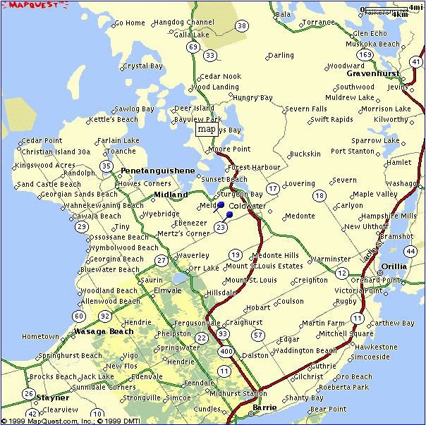
Figure 1. Map of the Simcoe County area (north towards top).
The blue pushpins indicate the start and end of the tornado track.
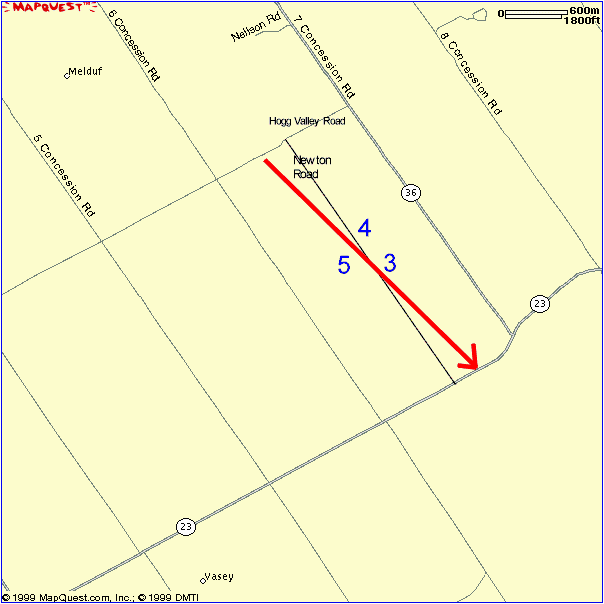
Figure 2. Higher resolution map of Melduf area with number labels
representing figure numbers for the photographs below.
North is towards the top.
Investigation
A ground investigation was conducted on Friday July 21. After asking
several of the locals about the damage, I was directed to the Newton Road
and Hogg Valley Road area. Just south of this intersection, tree damage
was increasingly evident. Trees were down from the south at the north end
of Newton Road but tree orientations gradually backed to the north toward
the south end of Newton Road. The track started about 200 m to the west
of the Newton Road near Hogg Valley Road but ended about 200 m to the east
of Newton Road near County Road 23 to the south. Along Newton Road, a 7
m x 20 m aluminum shed was picked up and tossed over 250 m toward the south
while trees about 200 m to the SSE were down from the north and northwest.
It was also reported that large bales of hay weighing around 500 kg were
moved about 300 m and a hay wagon was blown onto an elevator. There were
a few other instances of minor damage to houses and yard objects.
The tornado track and the orientation of trees and debris suggest a
cyclonically-rotating tornado moving from the north-northwest. In addition,
splattered mud covered a side of one house. This is typical of a tornado
as opposed to straight-line winds or microbursts. Several photos of damage
are included below.
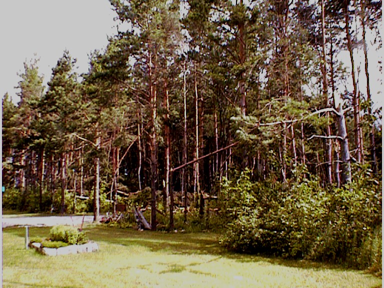
Figure 3. Numerous pine trees snapped from the west on east side
of Newton Road. Taken facing North.
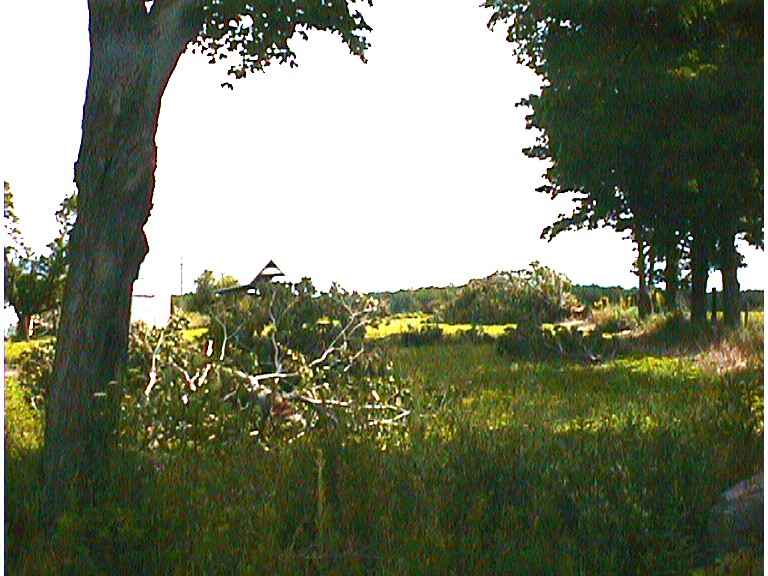
Figure 4. Two large trees snapped at their bases from the SSW
on east side of Newton Road. Taken facing NE.
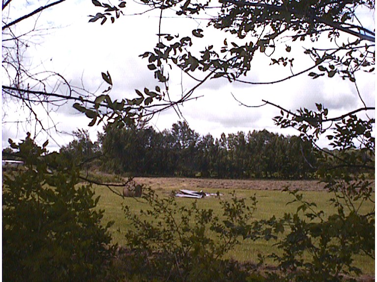
Figure 5. Debris from aluminum shed on west side of Newton
Road. Taken facing SW.
Judging by the other damage reports received on this day (given in Appendix
A), it seems that the reported time of this event is late at 1730 EDT.
An event time closer to 1700 EDT is probably more accurate but, since the
source was not recorded, this cannot be verified.
Conclusions
After analyzing the damage in this area, it was concluded that a cyclonically-rotating
tornado was responsible. This tornado had a track of about 3 km from approximately
315 degrees and a maximum path width of about 400 m. Damage consisted mainly
of snapped and uprooted trees, minor structural damage to buildings and
minor crop damage. One aluminum shed was tossed and destoyed. The intensity
of damage is consistent with F1 on the Fujita scale. There were no deaths
or injuries. Damage was estimated by the author at around $10 000.
Reference
Fujita, T.T. 1981. Tornadoes and Downbursts in the Context of Generalized
Planetary Scales. J. Atmos. Sci. 38:
1511-1534.
Appendix A - Abridged entries from severe weather log
SOURCE/WATCHER ID: Terry Darling
EVENT TIME (UTC): 20-15
EVENT LOCALE: Thornbury
ASOCTD PUBLIC RGN: Grey-Bruce
DETAILED DESCRIPTION: 80 km/h wind gusts, 30 sec duration.
SOURCE/WATCHER ID: Unknown
EVENT TIME (UTC): 20-30
EVENT LOCALE: Penetang
ASOCTD PUBLIC RGN: Barrie-Huronia
DETAILED DESCRIPTION: Golf ball sized hail
SOURCE/WATCHER ID: Dave Brain
EVENT TIME (UTC): 20-30
EVENT LOCALE: Midland
ASOCTD PUBLIC RGN: Barrie-Huronia
DETAILED DESCRIPTION: 1/4 to 1/2 inch diameter hail
SOURCE/WATCHER ID: Pirep (Pilot Report)
EVENT TIME (UTC): 20-30
EVENT LOCALE: YQA - Midland
ASOCTD PUBLIC RGN: Barrie-Huronia
DETAILED DESCRIPTION: UUA /OV CYEE 2035 FL SFC OBS/ SK 004 AGL OVC
XXX /RM VSBY 1/4 +RWGRF HAIL SIZE 1 TO 2 INCHES IN DIAMETER CB MVG ESE
SOURCE/WATCHER ID: Al Green
EVENT TIME (UTC): 20-30
EVENT LOCALE: Midland, Hwy 12 east of hwy 93
ASOCTD PUBLIC RGN: Barrie-Huronia
DETAILED DESCRIPTION: Golf ball sized hail for 5 minutes
SOURCE/WATCHER ID: Scott #1575
EVENT TIME (UTC): 20-36
EVENT LOCALE: 3 miles east of Midland (Port McNicoll)
ASOCTD PUBLIC RGN: Barrie-Huronia
DETAILED DESCRIPTION: marble sized hail, 1.5 - 2 cm hail, gusting winds
SOURCE/WATCHER ID: Dave Brain
EVENT TIME (UTC): 20-45
EVENT LOCALE: Rugby, 8 miles W of Orillia
ASOCTD PUBLIC RGN: Barrie-Huronia
DETAILED DESCRIPTION: 30 trees down (2 foot diameter), some N-S, some
NW-SE.
SOURCE/WATCHER ID: Canwarn
EVENT TIME (UTC): 20-52
EVENT LOCALE: 20 km N of Barrie
ASOCTD PUBLIC RGN: Barrie-Huronia
DETAILED DESCRIPTION: Lowering of cloud base, strong inflow, scud cloud
being sucked up.
SOURCE/WATCHER ID: via Sharon Hancock
EVENT TIME (UTC): 21-15
EVENT LOCALE: Coldwater
ASOCTD PUBLIC RGN: Barrie-Huronia
DETAILED DESCRIPTION: Pea sized hail, 50 km/h sustained winds
SOURCE/WATCHER ID: Unknown
EVENT TIME (UTC): 21-30
EVENT LOCALE: 8 KM NW OF COLDWATER
ASOCTD PUBLIC RGN: Barrie-Huronia
DETAILED DESCRIPTION: 200-300 TREES DOWNED (1/4 MI ED BY 1/2-1 MI LONG)..ORIENTED
MOSTLY NW-SE EXCEPT ON NORTHERN AREAS ORIENTED SW-NE; 1000 POUND BALES
OF HAY MOVED 800 FT HAY WAGON MOVED AND LEANING ONTO ELEVATOR ALUMINUM
SHED 20 FT X 60 FT MOVED ABOUT 700 FT FROM SOUTH
Appendix B - Watch and warning chronology
-
Special Weather Statement issued at 1621 EDT.
-
Severe Thunderstorm Warning issued for area at 1628 EDT. Standard mention
of possibility of tornadoes in bulletin.
-
Severe Thunderstorm Watch issued for area and surrounding regions at 1650
EDT.
-
Tornado Warning issued for area at 1719 EDT.