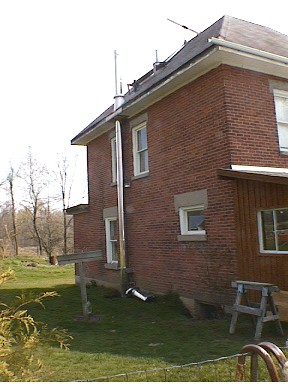
123 Hass Rd - facing S, chimney near
bottom of house
Investigator
David Sills, MSC King Radar
All photographs Copyright 1999 Environment Canada
Quick Facts
| Severe Weather Type | Tornado |
| Location | Hazzards Corners, Ontario - NE of Madoc |
| Time | 1615 EDT |
| Duration | Approx. 15 minutes |
| Magnitude | F0 |
| Path Length | Approx. 10 km |
| Direction of Motion | mainly from 0º though there was curvature |
| Path Width | Variable, maximum roughly 200 m |
| Significant Damage | Minor damage to house, roughly 100 trees down including numerous large trees with shallow root systems, one hydro pole down |
| Damage Estimate (Source) | $20 000
(DS) |
Overview
On 5 May 2000, a thunderstorm developed near Bancroft near 1915 UTC and moved toward the southeast. At 2040 UTC, a report of a tornado was received via the Madoc OPP by RCTO (see Appendix A). Only minor damage was reported.
A damage survey was conducted the following day, 6 May
2000. There was minor damage to a house and numerous trees felled from
various directions. It was concluded from the damage that an F0 tornado
travelled from roughly N to S over a distance of approximately 10 km. Additional
and subsequent information from witnesses supported this conclusion. The
author estimates the damage to be on the order of $20 000.
Investigation
The Madoc OPP related the location of damage and kindly provided detailed maps of the area. The first location visited was the home of Dean and Hilda Wehring at 123 Hass Road, roughly 5 km south of Cooper (a detailed map is provided near the end of the document). They had reported that their chimney was knocked off and that is shown in the picture below.
123 Hass Rd - facing S, chimney near
bottom of house
Roughly 20m to the west of the house, several large trees were blown down from the south, as shown in the picture below.
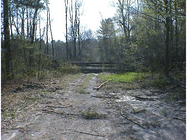
123 Hass Rd.- facing W, trees and debris across road
A bit farther down the road to the west, there was tree damage due to winds from the north, as shown by the photo below.
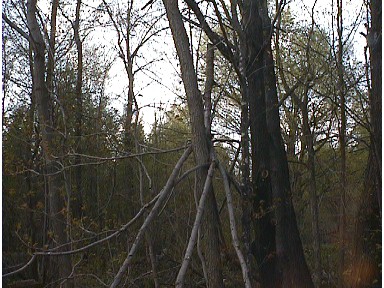
Hass Rd. - facing N, tree branch wedged into tree from N direction
Hilda Wehring said the storm came up at about 4:15 pm. At first it was windy with a lot of hail. Her husband opened the front door and encountered a whirlwind in the road. The screen door and a window were sucked from the house by the vortex. She related that roughly 100 trees, many large, were downed from various directions on their property approximately 1 km to the south of the house. She also said that the hail was about the size of a quarter and covered the ground.
Several other small pockets of felled trees were found on roads to the south of Hass Rd. Again, trees were down in various directions. On Queensborough Rd., which runs roughly east-west, there were numerous trees down from the north over a distance of roughly 1 km (see photo below). There was a hydro pole down about 1 km farther to the east.
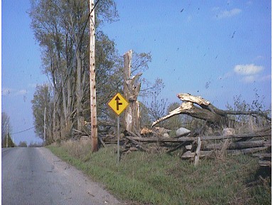
Queensborough Rd - facing E, large tree down
in foreground from north, second tree down
from north in background
There were also some metal siding panels found against a fence that appeared to be blown from the east or northeast. These are shown below.
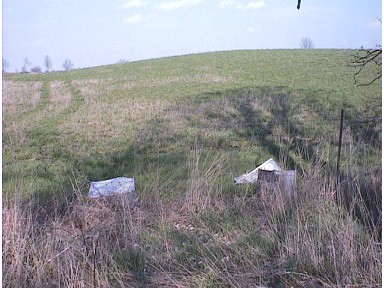
Harts Rd. - facing E, two metal siding panels
crumpled and against fence.
Peter Henderson observed a tornado at around 4 pm from the corner of Cooper and Queensborough Roads, appropriately known as Hazzards Corners. He described a dark, wedge-shaped cloud hanging from the thunderstorm with 5 or 6 vortices below sucking up dirt and debris. Looking north, he watched the tornado move to the east then curve south. He said that it then seemed to encounter winds from the south and began to move from the east more toward his location. He said he observed the tornado over a 10-15 minute period. At his location, there were light showers and frequent lightning. To his east, he said he saw a wall of white that he thought was hail.
There were also other reports in the media of sightings of two funnel clouds. Mr. Henderson said he saw only one.
Hunt Club Road - Facing N, very
mangy-looking coyote (or large red fox?)
Conclusions
After analyzing the damage and witness accounts, it was concluded that a tornado occurred causing damage consistent with F0 intensity on the Fujita scale (Fujita, 1981). There were several areas where trees were found downed in various directions along a narrow damage path. The trees' orientations appeared to be consistent with a cyclonically rotating vortex. The damage track appeared to begin near 123 Hass Rd. and ended approximately 10 km to the south just north of Highway 7 (see map below). According to a witness, the tornado motion was initially to the east, then to the south, then finally back toward the west possibly displaced by thunderstorm outflow. The maximum damage path width appeared to be roughly 200 m. The time of the event was approximately 1615 EDT with a duration of 10-15 minutes. There were no reports of injuries or deaths. Damage was estimated by the author to be on the order of $20 000.
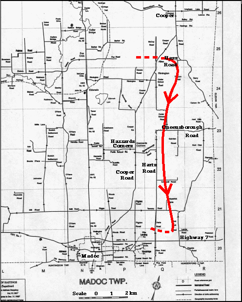
Map of tornado track - scale at bottom, courtesy OPP
Post Script
The author was fortunate enough to drive through this
same thunderstorm on Highway 401, sometime after the tornado had occurred.
The rain grew increasingly heavy moving toward the west and slushy hail
was briefly encountered. There appeared to be a lowering on the NW side
of the storm and possibly a 'beaver tail' cloud formation off to the north,
indicating that the inflow region may have been from the north side of
the storm.
Reference
Fujita, T.T. 1981. Tornadoes and Downbursts in the Context
of Generalized
Planetary Scales. J. Atmos. Sci.38:
1511-1534.
Appendix A
SOURCE/WATCHER ID: OPP
EVENT TIME (UTC): 20-40
EVENT DAY: 5.0
MONTH: 5.0
YEAR: 2000.0
EVENT LOCALE: N OF MADOC
ASOCTD PUBLIC RGN: Peterborough and the Kawarthas
DETAILED DESCRIPTION: TORNADO REPORTED TO OPP N OF MADOC MOVING TOWARD
TWEED.
TORNADO: POSSIBLE