I have started to put this page together to show various images of tornadoes
in Canada and discuss their nature. Since I have yet to actually see one
of these beasts in person (not that I haven't tried!), the photos are from
various sources and are properly credited. Please credit the appropriate
photographer if you happen to use any of these images.
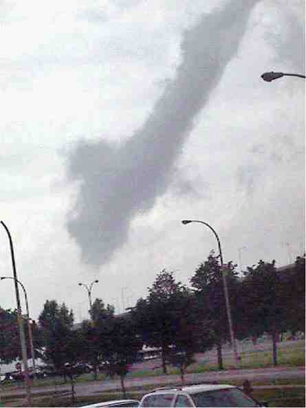
August 4, 1999
Tornado in Burlington, Ontario as photographed by Brent Malseed from the Canadian Centre for Inland Waters. This tornado occurred in association with a thunderstorm cell with a well-defined velocity couplet indicative of a mesocyclone. Interestingly, the radar echo tops on this storm ranged between 8 and 10 km - defintely a low-topped supercell! This tornado produced F2 damage earlier in Flamborough and north of Burlington.


Tornado photographed by Brian Michiel at Clear Creek (near Long Point).
Since the thunderstorm producing this tornado was out of King Doppler range,
it is difficult to tell if there was an associated mesocyclone. It is hard
to make out a defined wall cloud in the above pictures. Since this tornado
occurred so close to the lake, and since the cell motion was nearly stationary
as the tornado was reportedly occurring, I am tempted to think this
was a landspout or non-mesocyclone tornado occurring along the Lake Erie
lake breeze front. Unfortunately, their will never be enough evidence to
say one way or the other with any confidence.

Laura Duchesne and Dave Szozda of Kitchener captured from video this
image of a funnel cloud on March 28, 1998. Though difficult to see, the
funnel is near the top centre of the image and appears to be extending
nearly horizontally toward the left.
Last update: April 11 , 2000