|
|||||||||||||||||||||||||||||
|
|
|||||||||||||||||||||||||||||

|
|
|
| | VOLUME 32, NUMBER 13 | WEDNESDAY, MARCH 6, 2002 | ISSN 1199-5246 | |
|
|
||
|
|
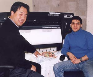
Professor Qiuming Cheng and post-doctoral fellow Alireza Panahi in the new geomatic research lab with high-tech equipment which can produce large maps and posters from computer data
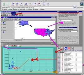
GeoDAS - geodata analysis system
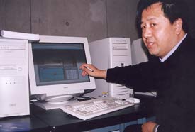
You'll probably never see a GeoDAS for Dummies book in the stores. But one day you might see a book on the subject by York Professor Qiuming Cheng of the departments of Earth & Atmospheric Science and Geography. Cheng is the man behind the advanced analysis tool.
The system that has stirred interest among renowned geologists worldwide is GeoDAS.
This high-tech tool, with its numerous new analytical techniques developed by Cheng and his research team, is rooted in GPS, GIS and remote-sensing technology. It is the fruit of Cheng's years of labour - of love - in the area of natural resources assessment and mathematical geography.
Cheng described GeoDAS as a "smart GIS system for spatial analysis of data pertaining to mineral exploration and environment assessment." Mathematics-based, it is a tool with many techniques currently not available in commercial geographic information systems. It can be used for everything from "managing information, visualizing, and doing spatial and statistical analyses to recognizing anomalies and integrating information for predictive purposes. And it enables people to do all of those procedures within a single system in a non-conventional manner," he added.
Internationally, people are hearing about GeoDAS and wanting to learn more about it. "In January we had our second training workshop on it at York," said Cheng. About 20 people from mining companies, the universities of Ottawa and Napoli, the Geological Survey of Canada (GSC) and the US Geological Survey (USGS) participated in the workshop, which was held in the Geomatics Research Lab in the basement of York's new Computer Science Building.
The lab was established with funds awarded jointly by the Canadian Foundation for Innovation, Ontario Research Development Challenge Fund and York, "and serves as the centre for geomatics research for the departments of Earth & Atmospheric Science and Geography and the Faculty of Environmental Studies," said Cheng who is the director of the lab.
He got the go-ahead for GeoDAS in 1997, and developed it with assistance from GSC and USGS. The project has been supported by a consortium of mining companies and the Ontario Premier's Research Excellence Awards.
How can GeoDAS help?
At present, GeoDAS is seen as a highly-sophisticated tool for geologists, particularly those in the mining industry, who use the system for sophisticated mapping of mineral potential (gold, silver, copper, zinc etc.) buried far under the earth's surface. At the same time, GeoDAS helps them predict the impact mining will have on the environment.
"You might find multiple sources of a certain element, for example arsenic or mercury," said Cheng. "Some of it could be natural and some could be a bi-product of human activities such as mining. GeoDAS helps us ascertain the sources of the elements."
As well as mapping elements for their origins, geologists can plot them against other attributes, such as their distance from cities, lakes, roads and slopes in the watershed context, to study the possible impact of toxic elements on the environment. Once the data is recorded on a GeoDAS computer program it can be transferred among charts, maps and tables.
"In an instant you can see the statistical patterns from the elements you recorded and their spatial relationships with other features on a map," he said. "You might be checking how other multiple layers of information relate to certain anomalies and you can integrate the data to predict the likelihood of similar sites occurring in another area."
Is GeoDAS useful in other fields?
GeoDAS would be useful in numerous areas, said Cheng. It could help farmers decide on the optimum concentration of elements needed for a good crop yield. In that case, people would collect soil samples, calculate the number and variety of elements in the samples, find out their sources, and check that information against current crop yields. Farmers would then know what elements were present where yields were high.
In the health field, GeoDAS could help people map and chart the likelihood of certain diseases occurring in a particular area. "You can see where a disease is prevalent and ascertain if its location is associated with such things as water quality, air quality, density of population and so on. And then we can use GeoDAS to help predict the occurrence of the disease in the future," he said.
Currently, Cheng and his research team at York use GeoDAS to forecast the location of mineral resources in Nova Scotia, Ontario and China. They also use it to predict where flowing water wells and springs can be found and analyze stream flow distribution and ground and surface water interaction in the Oak Ridges Moraine and Greater Toronto Area.
Because GeoDAS can be utilized in so many areas, it has become a multidisciplinary tool at York. Currently, it is used by graduate students in the Department of Earth & Atmospheric Science and the Department of Geography Geomatics Engineering Program. The Geomatics Research Lab will be the prime site for future training programs, workshops and seminars in the field.
For further information on GeoDAS visit the Web site:
www.gisworld.org/geodas
.
|
|
|
|
||
 GeoDAS: new "smart" tool at York stirs interest
|
|
|
| Current Issue | Previous Month | Past Issues | Rate Card | Contact Information | Search |
|