Open to Everyone
Learn how to use a drone for multispectral mapping with significant applications in industry

2026 Dates: Saturday, May 16 | July 11 | September 12 | November 14
Time: 9:00 AM-5:30 PM
Location: ADERSIM Lab, N004, Schulich Building, York University
Registration Deadlines for Each Course: Saturday May 9 | July 4 |
September 5 | November 7
Registration Links:
Saturday May 16 | Saturday July 11 | Saturday September 12 | Saturday November 14
Course Description
This course aims to give participants a thorough understanding of multispectral mapping and its drone applications. Combining classroom instruction, hands-on drone flying, and practical image analysis, it prepares learners to plan and execute multispectral surveys, gather quality data, and analyze multispectral images for real-world uses. By course end, participants will acquire both theoretical knowledge and practical skills applicable to sectors like agriculture, environmental monitoring, forestry, water resource management, and disaster risk reduction.
A microcredit certificate will be issued to all participants from CIFAL York upon completion of the course.
Course Outline

Learning Objectives
Gain a foundational understanding of multispectral imaging principles, including spectral bands and vegetation indices like NDVI, and their importance in environmental monitoring and resource management.
Discover the benefits of drone-mounted multispectral sensors – Familiarize yourself with various multispectral camera types, integration with drones, and optimal mission planning practices.
Operate drones to collect multispectral data – Develop hands-on skills in conducting safe and effective drone flights, capturing multispectral imagery in real-world conditions.
Process and analyze multispectral data by utilizing software tools to process raw drone imagery, generate vegetation indices, and create actionable maps.
Apply multispectral mapping to real-world scenarios to explore its applications in agriculture, forestry, water management, biodiversity monitoring, and disaster resilience.
Interpret and communicate findings—Learn to evaluate outputs, derive insights, and present results clearly and practically for decision-making.
Develop confidence in field-to-analysis workflows by completing the entire cycle from mission planning and data collection to processing and interpretation.

Course Approach
The course is structured into 3 modules. This three-module course is designed to balance theory with practice:
- Module 1: Classroom-based learning on the basics of multispectral mapping and drone-mounted multispectral systems.
- Module 2: Field training with drone flight missions to capture multispectral imagery.
- Module 3: Post-processing and analysis of multispectral data using industry-standard software.
.

Target Participants
Students and Early-Career Researchers in environmental science, disaster management, geography, agriculture, and engineering.
Professionals in agriculture, forestry, conservation, and water resource management seeking applied skills in drone-based multispectral mapping.
Government and NGO Staff involved in land use planning, biodiversity monitoring, and disaster risk reduction.
Drone Enthusiasts and Technologists interested in advancing from basic drone operations to specialized remote sensing applications.
Private Sector Practitioners from environmental consulting, precision agriculture, and technology firms seeking practical drone and data analysis skills.
.
Course Instructor

Dr. Ali Asgary
Professor Ali Asgary is an expert in disaster, emergency and business continuity management. He has been actively involved in research, teaching and professional activities in these fields since 1993. Since 2015, Dr. Asgary has been the executive director of York University's Advanced Disaster, Emergency and Rapid-response Simulation (ADERSIM). His research and teaching interests include post disaster recovery and reconstruction, business continuity and risk assessment, disaster and emergency simulations and modeling, applications of AI, VR, AR and MR, Drone, and geomatics in disaster and emergency management, and cost-benefit analysis and decision making under uncertainty. He holds Pilot Certificates for Basic, Advanced and Flight Review Operations of Remotely Piloted Aircraft Systems (RPAS), VLOS from Transport Canada.

Dr. Adyemi Olusola
Dr. Olusola is a river catchment scientist dedicated to understanding how natural and human factors shape river systems. Their research spans from headwater streams to large river basins such as the River Niger, exploring how floods, droughts, and human activities influence river dynamics and ecosystems. Combining field measurements, Earth observations, and machine learning, Dr. Olusola seeks to advance predictive understanding of river behavior under changing environmental pressures. As an educator, they are committed to equipping students with innovative, problem-driven research skills to address catchment and climate challenges and promote the sustainable management of river systems
Course Syllabus
Order of topics subject to change

Module 1: Basics of Multispectral Mapping (Classroom Session)
9:00-11:00
- Introduction to Multispectral Mapping
- Multispectral sensors capture light across multiple bands (visible & non-visible) to reveal insights not seen by the human eye. Used widely in agriculture, forestry, water monitoring, and biodiversity studies.
- Principles of Multispectral Imaging
- Different surfaces reflect light uniquely across bands. By analyzing these patterns, we can identify vegetation health, water quality, soil conditions, and environmental changes.
- Applications in Environmental Monitoring
- Multispectral mapping supports decision-making in conservation, agriculture, disaster management, and urban planning. Our Swan Lake project applies these techniques to study water health and biodiversity.
- Drones Equipped with Multispectral Sensors
- Platforms like DJI Mavic 3 Multispectral provide efficient, flexible, and high-resolution data collection for research and citizen science projects.
- ADERSIM & CIFAL York Projects Using Multispectral Mapping
- Swan Lake Citizen Science Lab: Mapping vegetation and water quality.
- Drone courses on applied environmental monitoring: Practical use cases in urban and rural ecosystems.

Module 2: Field Operations – Drone Flight for Multispectral Mapping
11:30-13:30
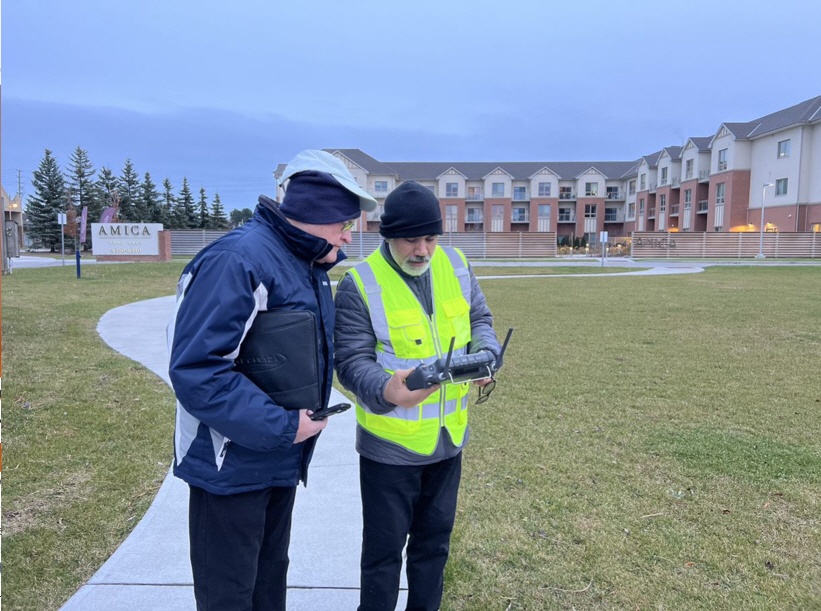
- Pre-Flight Planning
- Selecting the flight area, setting altitude, ensuring correct overlap, and considering solar conditions are critical for accurate data collection.
- Safety & Regulatory Considerations
- Safe operations require SFOC/SORA compliance, risk assessment, and flight planning – especially near sensitive infrastructure or higher altitudes.
- Mission Execution – Flying with Multispectral Drones
- Students will perform a supervised flight using DJI Mavic 3 Multispectral at Swan Lake or similar test areas.
- Data Capture Workflow
- Images are collected in multiple spectral bands and stored for later stitching into an Orthomosaic.
- Example from Past Projects
Drone-based biodiversity monitoring at Swan Lake – collected imagery used for vegetation index analysis (NDVI) and invasive species monitoring.

Module 3: Analysis of Multispectral Drone Data
14:30-17:30
- Data Processing Software
- Tools such as WEBODM and ArcGIS Pro are utilized to generate and process multispectral data, resulting in Orthomosaic, vegetation indices, and classified maps.
- Image Corrections & Calibration
- Accurate reflectance values are ensured through radiometric calibration. Correcting errors is crucial for maintaining consistent monitoring over time.
- Vegetation Indices & Applications
- NDVI, NDRE, and other indices provide insight into plant health, water stress, and ecosystem changes, as seen in the example of identifying stressed vegetation zones around Swan Lake.
- Practical Analysis Demonstration
- Students will examine actual collected datasets with ArcGIS, Pix4DMapper, and WEBODM, creating maps of vegetation health.
- Project Showcase & Future Applications
- Swan Lake Project – monitoring biodiversity and water quality.
- Exploring opportunities for collaboration with municipalities to monitor ecosystems and assess flood risks.
Registration and Payment
Registration and Payment Deadlines:
Saturday May 9 | July 4 | September 5 | November 7
Minimum enrollment to run each offering course: 10
Maximum enrollment: 40
Registration Fee
Full time students: CAN $50.00
Others: CAN$150.00
To register for this session and pay the fee:
Course Coordinator
Mx. Francesco del Carpio, CIFAL York
Mr. Mahbod Aarabi, ADERSIM