
Open to Everyone
Learn how to use a drone for thermal mapping with significant applications in industry

Date: November 7, 2026
Time: 9:00 AM - 5:30 PM ET
Location: ADERSIM Lab, N004, Schulich Building, York University
Registration Deadlines: October 31, 2026
Registration Link:


Course Description
This course aims to give participants a thorough understanding of thermal mapping, thermal image analysis, and its drone applications. Combining classroom instruction, hands-on drone flying, and practical image analysis, this hands-on course teaches students fundamental drone flight maneuvers, proper aerial thermal data acquisition techniques, and radiometric post-processing using DJI Thermal Analysis Tool 3. Designed for aspiring inspectors, technicians, and public safety personnel, participants will gain the practical skills needed to conduct aerial thermal audits across solar, electrical, roofing, and industrial infrastructure.
A microcredit certificate will be issued to all participants from CIFAL York upon completion of the course.
Course Outline
Learning Objectives
- Safe Drone Operation: Execute essential flight controls, automated mapping routes, and safety protocols for commercial inspection scenarios.
- Thermal Image Capture: Configure radiometric camera settings—including emissivity, reflected temperature, gain modes, and color palettes—to capture high-accuracy thermal data.
- Radiometric Post-Processing: Import and organize infrared datasets within DJI Thermal Analysis Tool 3.
- Defect Identification & Reporting: Apply spot meters, area measurements, and isotherm parameters to isolate temperature anomalies and export professional inspection reports.

Course Approach
The course is structured into 3 modules. This three-module course is designed to balance theory with practice:
- Module 1: Classroom-based learning on the basics of thermal mapping and drone-mounted thermal cameras.
- Module 2: Field training with drone flight missions to capture thermal imagery.
- Module 3: Post-processing and analysis of thermal images using the DJI Thermal Analysis Tool 3.
.

Target Participants
Students and Early-Career Researchers in heritage conservation, disaster risk management, structural/civil engineering, electronics, architecture, and urban planning.
Professionals in Heritage Preservation and Architecture, including conservators, historic building assessors, site managers, and facility technicians, are seeking non-destructive diagnostic skills.
Emergency Responders and Disaster Risk Personnel involved in rapid damage assessment, structural fire safety, post-disaster recovery, and heritage emergency planning
Government, Museum, and NGO Staff managing cultural assets, historical monuments, and land-use policies focused on climate adaptation and heritage resilience.
Drone Enthusiasts and Technologists aiming to transition from basic aerial photography to specialized radiometric inspection and thermal mapping.
Private Sector Practitioners from structural inspection, restoration contracting, energy auditing, and environmental consulting firms seeking applied thermography and data analysis skills.
.
Course Instructor
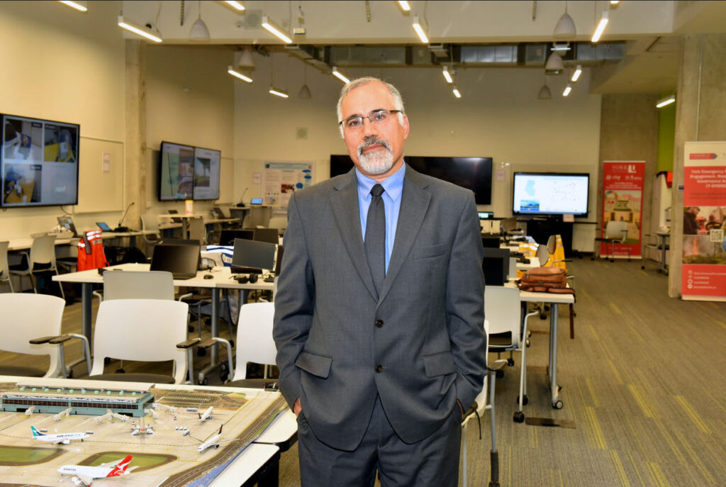
Dr. Ali Asgary
Professor Ali Asgary is an expert in disaster, emergency and business continuity management. He has been actively involved in research, teaching and professional activities in these fields since 1993. Since 2015, Dr. Asgary has been the executive director of York University's Advanced Disaster, Emergency and Rapid-response Simulation (ADERSIM). His research and teaching interests include post disaster recovery and reconstruction, business continuity and risk assessment, disaster and emergency simulations and modeling, applications of AI, VR, AR and MR, Drone, and geomatics in disaster and emergency management, and cost-benefit analysis and decision making under uncertainty. He holds Pilot Certificates for Basic, Advanced and Flight Review Operations of Remotely Piloted Aircraft Systems (RPAS), VLOS from Transport Canada.
Course Syllabus
Order of topics subject to change

Module 1: Basics of Thermal Mapping (Classroom Session)
9:00-11:00
- Introduction to Thermal Mapping
- Thermal cameras capture imagery by detecting infrared energy invisible to the human eye rather than reflecting ambient visible light. For aerial mapping, this raw energy is converted into calibrated, geographic data points.
- Principles of Thermal Mapping
- Every object emits infrared energy based on its temperature and material properties. By capturing and stitching these thermal signatures into a calibrated, geographic map, we can detect temperature variations that reveal structural defects, moisture leaks, energy loss, and equipment failures.
- Industry Applications
- Thermal mapping supports decision-making in solar asset management, infrastructure maintenance, building diagnostics, and emergency response. Inspection workflows apply these techniques to identify electrical faults, detect structural heat loss, and isolate moisture leaks before costly failures occur.
- Drones Equipped with Thermal Sensors
- Platforms like the DJI Mavic 3 Thermal provide efficient, flexible, and high-resolution radiometric data collection for infrastructure inspections and environmental monitoring.
- ADERSIM & CIFAL York Projects Using Thermal Mapping
- York University Energy Audits: Mapping buildings to pinpoint and improve efficiency to improve the institutional carbon footprint.
- Heritage Emergency and Resilience Lab: Radiometric mapping is a non-invasive tool for rapid damage assessments, thermal stress and moisture mapping, fire risk auditing, and post-disaster reconstruction.

Module 2: Field Operations – Drone Flight for Thermal Mapping
11:30-13:30
- Pre-Flight Planning
- Selecting the flight area, setting altitude, ensuring correct overlap, and considering solar conditions are critical for accurate data collection.
- Safety & Regulatory Considerations
- Safe operations require SFOC/SORA compliance, risk assessment, and flight planning – especially near sensitive infrastructure or higher altitudes.
- Mission Execution – Flying with Thermal Drones
- Students will perform a supervised flight using a DJI Mavic 3 Thermal drone.
- Data Capture Workflow
- Radiometric thermal imagery collected and stored for later analysis and report generation.
- Example from Past Projects
- Drone-based thermal monitoring and analysis of York University's Keele campus buildings for improving energy efficiency and reducing emissions.

Module 3: Analysis of Thermal Drone Data
14:30-17:30
- Data Processing Software
- Tools such as the DJI Thermal Analysis Tool 3 are specialized post-processing software designed to view, measure, and analyze radiometric thermal imagery captured by DJI enterprise drones and payloads. These software allows users to extract and interpret temperature data back on a computer.
- Precise Temperature Measurement
- Add spot meters, lines, and area boxes (rectangles or polygons) to read exact maximum, minimum, and average temperatures across specific components.
- Parameter Adjustments
- Modify environmental variables after the flight—such as emissivity, reflection temperature, relative humidity, and target distance—to calibrate and refine temperature accuracy.
- Palette & Isotherm Tuning
- Switch between thermal color palettes (e.g., Iron Red, Rainbow, White Hot) and set isotherm bands to visually highlight areas that exceed or fall below designated temperature thresholds.
- Anomaly Detection
- Pinpoint thermal anomalies that indicate underlying issues, such as defective solar cells, overheated electrical transformers, structural heat leaks, or water ingress under flat roofs.
- Report Generation
- Export structured inspection reports, annotated images, and temperature data tables to deliver actionable documentation to clients and maintenance teams.
Registration and Payment
Registration and Payment Deadline: October 31, 2026
Minimum enrollment to run each offering course: 10
Maximum enrollment: 40
Registration Fees
General Registration Fee: CAN $200.00
Full-time Student Registration Fee: CAN $100.00
To register for this session and pay the fee:
Course Coordinator
Mx. Francesco del Carpio, CIFAL York
Mr. Mahbod Aarabi, ADERSIM